
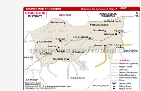
Udalguri District
About the District
Udalguri district, also known as Odalguri, is a district in the Bodoland Territorial Region of Assam in North-East India. Udalguri town is the district headquarters.
The district shares an international border with Bhutan and a state border with Arunachal Pradesh to the north. It is well connected by road and rail.
The district was formed on 14 June 2004 as one of the four districts under the Bodoland Territorial Council, by bifurcating Darrang district. Its territory was earlier the Udalguri sub-division of undivided Darrang.
The district is home to people of many communities and faiths living together. Late Jojaram Sharma, one of the prominent freedom fighters from Assam, lived here.
Boundaries and Administrative Units
Sub-divisions 2
- Udalguri
- Bhergaon
Revenue Circles 5
- Udalguri
- Majbat
- Harisinga
- Kalaigaon
- Khoirabari
How Udalguri Got Its Name
There are several views on the origin of the name. One holds that it means a place surrounding the Udal tree (Udal, a tree, and guri, the surrounding area). Another says the place took its name from the hermitage of a sage named Uddalak Muni.
The most widely accepted view traces the name to the Bodo language, from the words ordla, meaning wide and spacious, and gundri, meaning a powdered object. In earlier times, rivers such as the Golondi, Khaorong, Doisam and Dhansiri flooded the area every monsoon and left it covered in sand, so the name may describe a vast, sandy place. Bodo people still pronounce the name as Odalguri.
Population and Communities
According to the 2011 Census, Udalguri district has a population of 8,31,668, an increase of 9.8 per cent over 2001. The literacy rate is 66.6 per cent.
The district is multi-ethnic and multi-religious. Bodos form the largest community at 33.76 per cent of the population, followed by the Adivasi community at about 23.12 per cent and Bengali Muslims at about 12 per cent. Assamese and Bengali Hindus live mainly in urban areas, and a Nepali-speaking Gorkha community of about 5 per cent is spread across the district.
Places of Interest
Besides the rich culture and traditions of its many communities, the district has several places worth visiting.
History of Udalguri
-
Ancient times
Gateway of the route to Tibet
Scholars record an ancient route from Udalguri through Bhairabkunda and the Bhutan hills to Tibet, China and beyond. Sir Edward Gait described it as the shortest route from Udalguri to Tibet. Its gate at Bhairabkunda was known as Kariapara Duar. The route was also used by Buddhist monks, Naths, yogis and tantriks, making it important for cultural exchange as well as trade.
Exports from AssamEndi cloth, muga silk, gold, rice, iron, buffalo horns, animal skins, lac and dry fishImports to AssamIvory, sulphur, musk, dyes, silver, rock salt, blankets, woollens and Chinese silk -
1205-06 AD
Raonagar rampart
When Muhammad bin Bakhtiyar marched through Kamrup towards Tibet, he is believed to have used this route and was defeated near a large rampart below the hills. This is thought to be Raonagar, about 13 km south of the Bhutan hills and 9 km west of Udalguri. Its ruins, spread over more than 600 bigha with ten tanks inside, can still be seen.
-
1562 AD
Koch King Naranarayan
During his campaign against the Ahom kingdom, Koch King Naranarayan ordered a temple of Goddess Durga at Nalkhamara and a hill fort to be built near Bhairabkunda.
-
Early 1900s
Early settlement
Udalguri once comprised villages such as Puronithana, Angragaon and Niz-Udalguri. The present town stands on land formed by sand deposited by the Golondi, Khaorong and Doisam rivers. Nepali graziers were among the first settlers, and in 1901 a Marwari trader opened a grocery shop at Thana Udalguri. The police station was moved from Puronithana to near the railway station in 1913.
-
1930s
Railway and new settlers
The railway from Tangla through Udalguri to Rangapara was built in 1932-33, and passenger trains began running in 1935. Bodo families from undivided Goalpara and Kamrup, and Assamese families from Nalbari and Barpeta, settled in the area, and a Namghar was built in 1935-36.
-
1942 to 1950s
Freedom movement and new institutions
The Quit India Movement of 1942 reached Udalguri, with about 100 Congress workers holding a meeting here on 8 October. After 1947, Bengali Hindu families settled around the railway station. The Block Development Office opened in 1952, the primary health centre in 1954, and Udalguri High School in 1956.
-
1962
Chinese aggression
As the gateway to the route to Tibet, Udalguri became strategically important during the Chinese aggression. Thousands of refugees came down from the hills through Kariapara Duar, army bunkers were built in the fields, and a defence road was built from Tamulpur to Bhairabkunda. From this time, Udalguri became known across India.
-
2003 to 2004
Birth of the district
After the Memorandum of Settlement of 10 February 2003 between the Bodo Liberation Tigers, the Government of India and the Government of Assam, the Bodoland Territorial Council was created under the Sixth Schedule of the Constitution. Udalguri was notified as a district on 30 October 2003 and formally inaugurated on 14 June 2004.